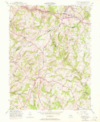
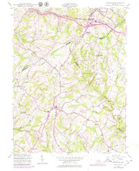
1944 Map of Damascus
USGS Topo · Published 1971About this map
Damascus serves as a central hub on this mid-century survey, which reveals the rural crossroads and drainage patterns along the high ground of the Maryland Piedmont. The landscape is defined by the headwaters of several major systems, including Great Seneca Creek, Little Bennett Creek, and the Patuxent River. Transportation is anchored by the Baltimore and Ohio corridor running through the northern sector, passing through Mount Airy and Ridgeville. This area is characterized by small, established agricultural settlements like Claggettsville, Kemptown, and Browningsville, many of which developed along the ridges separating the narrow stream valleys. The map documents a significant border region where four counties—Frederick, Carroll, Howard, and Montgomery—converge near Parrsville and Parrs Spring, illustrating how historical land grants and natural watersheds influenced local political boundaries and early settlement patterns.
Find a feature on this map
35 named features on this map. Tap any name to fly to it.
Don’t see what you’re looking for? This feature index may not catch every label — zoom into the map to look around manually.
Map Details
Editions of this 1944 Damascus Map
5 editions found
Other maps of this area

1893 · Frederick
USGS Topo · 1:125,000

1894 · Frederick
USGS Topo · 1:125,000

1908 · Rockville
USGS Topo · 1:62,500

1908 · Seneca
USGS Topo · 1:62,500

1908 · Ijamsville
USGS Topo · 1:62,500

1909 · Mount Airy
USGS Topo · 1:62,500

1909 · Ijamsville
USGS Topo · 1:62,500

1923 · Rockville
USGS Topo · 1:62,500

1942 · Frederick
USGS Topo · 1:62,500

1944 · Walkersville
USGS Topo · 1:31,680