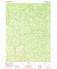
1982 Map of Damnation Peak
USGS Topo · Published 1982About this map
The Trinity Mountains dominate this 1982 survey of the rugged Shasta-Trinity border, revealing a landscape shaped by early industry and seasonal ranching. The presence of the Lamoine Mill (Site) and the Tollhouse along the eastern slopes suggests a legacy of timber extraction and mountain transit, while temporary outposts like Heavey Sheep Camp and Sugar Pine Sheep Camp indicate the grazing patterns of the era. The northwestern corner is defined by the expansive Clair Engle Lake and Lewiston Lake, which stand in contrast to the high, dry ridges like McKinsey Ridge and Topnotch Ridge. From the depths of Damnation Creek to the summit of Damnation Peak, the map documents a transition from the water-rich recreation areas of the Whiskeytown-Shasta-Trinity National Recreation Area to the mining history found at Caves Mine.
Find a feature on this map
55 named features on this map. Tap any name to fly to it.
Don’t see what you’re looking for? This feature index may not catch every label — zoom into the map to look around manually.
Map Details
Editions of this 1982 Damnation Peak Map
This is the sole edition of this map. No revisions or reprints were ever made.
Other maps of this area

1886 · Shasta
USGS Topo · 1:250,000

1890 · Red Bluff
USGS Topo · 1:250,000

1894 · Red Bluff
USGS Topo · 1:250,000

1894 · Shasta
USGS Topo · 1:250,000

1901 · Redding
USGS Topo · 1:125,000

1913 · Weaverville
USGS Topo · 1:125,000

1923 · Sawyers Bar
USGS Topo · 1:125,000

1931 · Etna
USGS Topo · 1:96,000

1934 · Etna
USGS Topo · 1:125,000

1935 · Dunsmuir
USGS Topo · 1:125,000