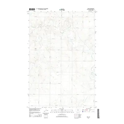
2014 Map of Dana
USGS Topo · Published 2014About this map
Dana sits at the center of this rural Emmons County landscape, where the prairie is defined by a rhythmic grid of section-line roads and winding drainages. The topography is shaped by the meandering paths of Long Lake Cr and Hawk Cr, which carve gentle depressions across the township. In the eastern portion of the map, the Braddock Dam structures the flow of the W Br Long Lake Cr, creating a rare point of engineered water management in this agricultural region. The map reveals a highly organized 21st-century road network, including corridors like 11th Ave SE and 60th St SE, that supports the sparse settlement pattern characteristic of North Dakota's grain and ranching country. For those tracing the evolution of local townships, this 2014 survey document shows the enduring layout of rural sections and the persistence of named water features like Goose Cr and the various branches of the Long Lake watershed.
Find a feature on this map
21 named features on this map. Tap any name to fly to it.
Don’t see what you’re looking for? This feature index may not catch every label — zoom into the map to look around manually.
Map Details
Editions of this 2014 Dana Map
This is the sole edition of this map. No revisions or reprints were ever made.
Other maps of this area

1954 · Bismarck
USGS Topo · 1:250,000

1958 · Bismarck
USGS Topo · 1:250,000

1971 · Hazelton
USGS Topo · 1:24,000

1971 · Moffit SE
USGS Topo · 1:24,000

1971 · Moffit
USGS Topo · 1:24,000

1975 · Dana
USGS Topo · 1:24,000

1975 · Appert Lake
USGS Topo · 1:24,000

1975 · Linton NE
USGS Topo · 1:24,000
1975 · Braddock NW
USGS Topo · 1:24,000

1975 · Braddock
USGS Topo · 1:24,000