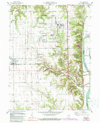
1978 Map of Dana
USGS Topo · Published 1990About this map
The Newport Army Ammunition Plant dominates the landscape of Vermillion County in the late 1970s, occupying a massive footprint north of the Baltimore and Ohio Railroad. This industrial and military concentration contrasts with the agricultural grid surrounding the town of Dana, where the terrain transitions into the dissected bluffs of the Wabash River valley. Along the river's western bank, industrial activity is evident at the Clay Pits near Highland, while the river itself marks the boundary with Parke County at Montezuma. The map reveals a high density of small family and community burial grounds, including Walnut Hill Cem, Carmack Cem, and Hollingsworth Cem, which offer significant value for genealogical research. Cultural landmarks such as the Ernie Pyle Rest Park and the junction of major rail lines at Hillsdale further define this intersection of Indiana's military, industrial, and rural history.
Find a feature on this map
48 named features on this map. Tap any name to fly to it.
Don’t see what you’re looking for? This feature index may not catch every label — zoom into the map to look around manually.
Map Details
Editions of this 1978 Dana Map
4 editions found
Other maps of this area

1947 · Ridge Farm
USGS Topo · 1:62,500

1947 · Paris
USGS Topo · 1:62,500

1949 · Paris
USGS Topo · 1:62,500

1951 · Clinton
USGS Topo · 1:24,000

1951 · Mecca
USGS Topo · 1:24,000

1951 · Saint Bernice
USGS Topo · 1:24,000

1953 · Indianapolis
USGS Topo · 1:250,000

1955 · Kingman
USGS Topo · 1:24,000

1955 · Humrick
USGS Topo · 1:24,000

1955 · Scottland
USGS Topo · 1:24,000