
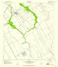
1943 Map of Danbury
USGS Topo · Published 1943About this map
Danbury serves as the central hub of this coastal Texas landscape, where the Missouri Pacific railroad cuts a diagonal line through the low-lying terrain. The area is defined by its intricate drainage patterns, with the meandering courses of Flores Bayou, Austin Bayou, and Brushy Bayou weaving across the map. These natural waterways are complemented by man-made alterations, notably the industrial Pumping Station located along the banks of Eagle Gully, reflecting the region's reliance on water management for agriculture and industry in the early 1940s.
Find a feature on this map
14 named features on this map. Tap any name to fly to it.
Don’t see what you’re looking for? This feature index may not catch every label — zoom into the map to look around manually.
Map Details
Editions of this 1943 Danbury Map
2 editions found
Other maps of this area

1932 · Mustang Bayou
USGS Topo · 1:31,680

1943 · Oyster Creek
USGS Topo · 1:31,680

1943 · Rosharon
USGS Topo · 1:31,680

1943 · Mustang Bayou
USGS Topo · 1:31,680

1943 · Angleton
USGS Topo · 1:24,000

1943 · Christmas Point
USGS Topo · 1:24,000

1943 · Chocolate Bay
USGS Topo · 1:24,000

1943 · Chocolate Bayou
USGS Topo · 1:24,000

1943 · Snipe
USGS Topo · 1:31,680

1950 · Houston
USGS Topo · 1:250,000