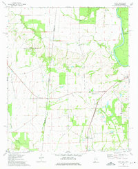
1974 Map of Dancy
USGS Topo · Published 1975About this map
The Mississippi-Alabama state line divides this 1970s landscape, where the Tombigbee River meanders along the eastern edge of Pickens Co. The settlement pattern is defined by the St Louis-San Francisco railroad, which anchors the communities of Cochrane and Dancy. Numerous rural landmarks suggest a long-established community structure, including Rock Hill Ch and Hebron Ch, along with the Cluster Cem. The terrain is characterized by the winding paths of Bogue Chitto and Fennache Creek, which flow through the western wetlands. This survey captures a specific moment in the rural South, showing the proximity of the Noxubee-Pickens county boundary and the transition from riverine lowlands to upland clusters like Dinsmore and Woodwards.
Find a feature on this map
21 named features on this map. Tap any name to fly to it.
Don’t see what you’re looking for? This feature index may not catch every label — zoom into the map to look around manually.
Map Details
Editions of this 1974 Dancy Map
2 editions found
Other maps of this area

1953 · Meridian
USGS Topo · 1:250,000

1953 · West Point
USGS Topo · 1:250,000

1957 · Meridian
USGS Topo · 1:250,000

1958 · West Point
USGS Topo · 1:250,000

1963 · West Point
USGS Topo · 1:250,000

1965 · Meridian
USGS Topo · 1:250,000

1970 · Aliceville North
USGS Topo · 1:24,000

1970 · Aliceville South
USGS Topo · 1:24,000

1970 · Warsaw
USGS Topo · 1:24,000

1973 · Panola
USGS Topo · 1:24,000