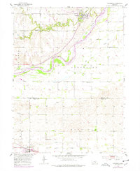
1953 Map of Dannebrog
USGS Topo · Published 1977About this map
Dannebrog sits at the confluence of Oak Creek and the Loup River, serving as a central point in this 1950s agrarian landscape. The river system, including the Middle Loup River and Big Slough, dominates the terrain, while the Union Pacific and Burlington Northern railroads provide the vital transit links to Cairo. This survey, updated with mid-1970s revisions, illustrates a transition in rural education and land use.
Find a feature on this map
28 named features on this map. Tap any name to fly to it.
Don’t see what you’re looking for? This feature index may not catch every label — zoom into the map to look around manually.
Map Details
Editions of this 1953 Dannebrog Map
2 editions found
Other maps of this area

1892 · Grand Island
USGS Topo · 1:62,500

1895 · Grand Island
USGS Topo · 1:62,500

1895 · Wood River
USGS Topo · 1:62,500

1896 · Wood River
USGS Topo · 1:125,000

1898 · Grand Island
USGS Topo · 1:125,000

1899 · Loup
USGS Topo · 1:125,000

1899 · St. Paul
USGS Topo · 1:125,000

1953 · Dannebrog
USGS Topo · 1:24,000

1953 · Boelus
USGS Topo · 1:24,000

1953 · Farwell
USGS Topo · 1:24,000