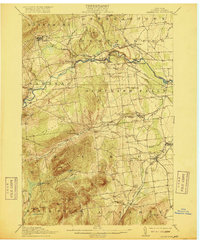
1913 Map of Dannemora
USGS Topo · Published 1916About this map
State Penitentiary anchors the high ground of Clinton County in this early twentieth-century survey, looking out over a landscape defined by the winding Saranac River and the steep slopes of Terry Mountain. The industrial and agricultural patterns of the era are evident in the cluster of small communities and the proximity of the Delaware and Hudson RR, which follows the river valley through Cadyville and Morrisonville. In the southern reaches of the quadrangle, the Ausable River and Little Ausable River provide the drainage for more dispersed settlements like Harkness and Lapham Mills. Local education is prominently marked by a network of rural schoolhouses, including the Rand Hill School and Patton School, while the presence of Mt Etna and Mitchell Mtn highlights the transition from the valley floor to the Adirondack foothills.
Find a feature on this map
54 named features on this map. Tap any name to fly to it.
Don’t see what you’re looking for? This feature index may not catch every label — zoom into the map to look around manually.
Map Details
Editions of this 1913 Dannemora Map
5 editions found

Other maps of this area

1894 · Plattsburg
USGS Topo · 1:62,500

1895 · Mooers
USGS Topo · 1:62,500

1895 · Rouse Point
USGS Topo · 1:62,500

1895 · Willsboro
USGS Topo · 1:62,500

1895 · Ausable
USGS Topo · 1:62,500

1896 · Lake Placid
USGS Topo · 1:62,500

1898 · Lake Placid
USGS Topo · 1:62,500

1899 · Mooers
USGS Topo · 1:62,500

1903 · Ausable
USGS Topo · 1:62,500

1906 · Plattsburg
USGS Topo · 1:62,500