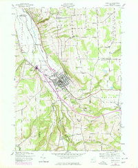
1942 Map of Dansville
USGS Topo · Published 1978About this map
Dansville serves as the focal point of this Genesee Valley landscape, where the confluence of rail, air, and water transport shaped local development. The presence of the Dansville and Mount Morris road and the Dansville Station highlight the era's reliance on railway connections, while the Dansville Airport signals the mid-century transition to modern infrastructure. Beyond the village center, the terrain is marked by dramatic geological features like Stony Brook Glen and Stone Falls, which are protected within Stony Brook State Park.
Find a feature on this map
55 named features on this map. Tap any name to fly to it.
Don’t see what you’re looking for? This feature index may not catch every label — zoom into the map to look around manually.
Map Details
Editions of this 1942 Dansville Map
5 editions found
Other maps of this area

1902 · Wayland
USGS Topo · 1:62,500

1904 · Wayland
USGS Topo · 1:62,500

1905 · Nunda
USGS Topo · 1:62,500

1915 · Hornell
USGS Topo · 1:62,500

1916 · Canaseraga
USGS Topo · 1:62,500

1918 · Hornell
USGS Topo · 1:62,500

1940 · Canaseraga
USGS Topo · 1:62,500

1942 · Springwater
USGS Topo · 1:31,680

1942 · Wayland
USGS Topo · 1:31,680

1942 · Dansville
USGS Topo · 1:31,680