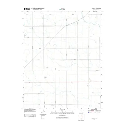
2012 Map of Danville
USGS Topo · Published 2012About this map
Danville and Runnymede anchor this agricultural landscape in northeastern Harper County, where the plains are etched by the meandering courses of the Chikaskia River and Spring Cr. The settlement pattern follows a rigid section-line grid, typical of the Kansas prairie, yet it is broken by the diagonal path of Highway 2. Local history is preserved at Pleasant Valley Cem and Cavalry Cem, while the agrarian economy is punctuated by small-scale aviation facilities like Bob Park Airport and Kaypod Airport. The southern portion of the quadrangle is defined by the drainage of Sand Cr and Silver Cr, illustrating the subtle topography of the Red Hills region. This survey captures a moment where traditional rural infrastructure, centered on the post office at Danville, persists alongside modern road networks like Ne 100 RD and Ne 40 Ave.
Find a feature on this map
28 named features on this map. Tap any name to fly to it.
Don’t see what you’re looking for? This feature index may not catch every label — zoom into the map to look around manually.
Map Details
Editions of this 2012 Danville Map
This is the sole edition of this map. No revisions or reprints were ever made.
Other maps of this area

1889 · Anthony
USGS Topo · 1:125,000

1889 · Caldwell
USGS Topo · 1:125,000

1891 · Anthony
USGS Topo · 1:125,000

1893 · Caldwell
USGS Topo · 1:125,000

1897 · Caldwell
USGS Topo · 1:125,000

1955 · Wichita
USGS Topo · 1:250,000

1955 · Pratt
USGS Topo · 1:250,000

1958 · Wichita
USGS Topo · 1:250,000

1959 · Pratt
USGS Topo · 1:250,000
1971 · Norwich
USGS Topo · 1:24,000