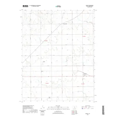
2018 Map of Danville
USGS Topo · Published 2018About this map
Danville serves as the primary hub for this rural stretch of Harper County, where the plains are defined by a meticulous grid of section roads and the winding paths of Spring Cr and Sand Cr. To the north, the small settlement of Runnymede reflects the area's agricultural character, while local landmarks like the Pleasant Valley Cem and Cavalry Cem provide vital links for those researching regional family history and genealogy. Aviation is represented by two small airstrips, Bob Park Airport and Kaypod Airport, which stand out against the expanse of farmland. The geography is marked by the transition between several townships, including t31s r6w and t32s r5w, illustrating the organized land division typical of the Kansas prairie in the early 21st century.
Find a feature on this map
33 named features on this map. Tap any name to fly to it.
Don’t see what you’re looking for? This feature index may not catch every label — zoom into the map to look around manually.
Map Details
Editions of this 2018 Danville Map
This is the sole edition of this map. No revisions or reprints were ever made.
Other maps of this area

1889 · Anthony
USGS Topo · 1:125,000

1889 · Caldwell
USGS Topo · 1:125,000

1891 · Anthony
USGS Topo · 1:125,000

1893 · Caldwell
USGS Topo · 1:125,000

1897 · Caldwell
USGS Topo · 1:125,000

1955 · Wichita
USGS Topo · 1:250,000

1955 · Pratt
USGS Topo · 1:250,000

1958 · Wichita
USGS Topo · 1:250,000

1959 · Pratt
USGS Topo · 1:250,000
1971 · Norwich
USGS Topo · 1:24,000