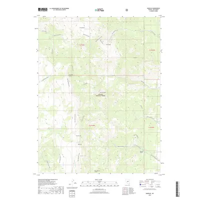
2018 Map of Danville
USGS Topo · Published 2018About this map
Toiyabe National Forest encompasses the high-altitude terrain of the Monitor Range in this section of Nye County. The landscape is defined by its dramatic relief, where Tulle Mtn and Table Mtn rise above a series of deep drainage systems including Green Monster Canyon, Cottonwood Canyon, and Tulle Canyon. Water sources like Morgan Spring and the small Clear Lake are vital markers in this arid environment, often found near the complex network of trails and secondary roads that traverse the slopes.
Find a feature on this map
35 named features on this map. Tap any name to fly to it.
Don’t see what you’re looking for? This feature index may not catch every label — zoom into the map to look around manually.
Map Details
Editions of this 2018 Danville Map
This is the sole edition of this map. No revisions or reprints were ever made.
Other maps of this area

1956 · Tonopah
USGS Topo · 1:250,000

1959 · Tonopah
USGS Topo · 1:250,000

1962 · Tonopah
USGS Topo · 1:250,000

1967 · Upper Fish Lake
USGS Topo · 1:24,000

1968 · Morey Peak
USGS Topo · 1:62,500

1968 · Fish Springs
USGS Topo · 1:62,500
1968 · Stargo Creek
USGS Topo · 1:24,000
1968 · Fish Springs
USGS Topo · 1:24,000

1971 · Barley Creek
USGS Topo · 1:24,000

1971 · Mosquito Creek
USGS Topo · 1:24,000