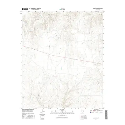
2016 Map of Dark Canyon
USGS Topo · Published 2016About this map
The South Wichita River winds through the northern portion of this King County landscape, carving a complex drainage system that defines the local topography. This 2016 survey captures a primarily rural expanse dominated by seasonal watercourses and deep incisions in the earth, most notably Dark Canyon and Spring Canyon. The network of creeks, including Newman Cr, Ash Cr, and Little Buffalo Cr, illustrates the hydrological pattern typical of the Rolling Plains, where water management is marked by features like the Dark Canyon Tank. Transport through this cattle-ranching country is limited to a few secondary routes such as Co RD 257 and Co RD 328, which intersect with the primary corridor of Highway 82 and Highway 114. The map reveals a landscape where human footprint is minimal, focused largely on the management of water and range land across the various forks of Croton Cr.
Find a feature on this map
17 named features on this map. Tap any name to fly to it.
Don’t see what you’re looking for? This feature index may not catch every label — zoom into the map to look around manually.
Map Details
Editions of this 2016 Dark Canyon Map
This is the sole edition of this map. No revisions or reprints were ever made.
Other maps of this area

1954 · Lubbock
USGS Topo · 1:250,000

1959 · Bob Creek
USGS Topo · 1:24,000

1966 · Ox Yoke Creek
USGS Topo · 1:24,000

1966 · J Y Ranch
USGS Topo · 1:24,000

1967 · Dark Canyon
USGS Topo · 1:24,000

1967 · Fourmile Hill
USGS Topo · 1:24,000

1967 · Kiowa Peak NW
USGS Topo · 1:24,000

1967 · Kiowa Peak NE
USGS Topo · 1:24,000
1967 · Buzzard Peak
USGS Topo · 1:24,000

1968 · Guthrie
USGS Topo · 1:24,000