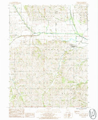
1985 Map of Darlington
USGS Topo · Published 1986About this map
The Grand River and its complex network of tributaries, including the Middle Fork and Wildcat Creek, define the landscape of south-central Gentry County in the mid-1980s. The village of Darlington sits on higher ground south of the river, while the small settlements of Mc Curry and Carmack are positioned near the valley floor. Evidence of the region's transportation history is preserved through the Old RR Grade, which formerly connected these rural communities along the river corridor.
Find a feature on this map
20 named features on this map. Tap any name to fly to it.
Don’t see what you’re looking for? This feature index may not catch every label — zoom into the map to look around manually.
Map Details
Editions of this 1985 Darlington Map
This is the sole edition of this map. No revisions or reprints were ever made.
Other maps of this area

1925 · Stanberry
USGS Topo · 1:62,500

1925 · Darlington
USGS Topo · 1:62,500

1939 · Stanberry
USGS Topo · 1:62,500

1940 · Parnell
USGS Topo · 1:62,500

1942 · Grant City
USGS Topo · 1:62,500

1943 · Parnell
USGS Topo · 1:62,500

1943 · Grant City
USGS Topo · 1:62,500

1943 · Stanberry
USGS Topo · 1:62,500

1950 · Darlington
USGS Topo · 1:62,500

1955 · Nebraska City
USGS Topo · 1:250,000
Featured Places
- Darlington, Cooper Township
- Cooper Township, MO
- Jackson Township, MO
- Huggins Township, MO
- Miller Township, MO