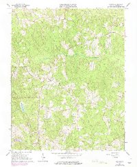
1964 Map of Darvills
USGS Topo · Published 1975About this map
Darvills serves as a central hub for this rural Dinwiddie County landscape during the mid-1960s, a region characterized by its network of historic country churches and the sprawling western boundary of the Camp Pickett Military Reservation. The map details a predominantly agricultural and timbered terrain where social life was anchored by congregations at Butterwood Ch, Sharon Ch, and Shaloh Ch. Notable landmarks like the Hawkins Memorial and the Darvills Community Center reflect the local heritage and community structure of the era. The land is drained by a dense system of waterways including White Oak Creek and Butterwood Creek, while the military reservation contains specialized features such as Tommeheton Lake and various observation towers used for training operations. Small settlements like Eta and Birchin appear as quiet rural junctions connected by a winding network of light-duty and unimproved roads.
Find a feature on this map
25 named features on this map. Tap any name to fly to it.
Don’t see what you’re looking for? This feature index may not catch every label — zoom into the map to look around manually.
Map Details
Editions of this 1964 Darvills Map
3 editions found
Other maps of this area

1897 · Amelia
USGS Topo · 1:125,000

1918 · Lawrenceville
USGS Topo · 1:62,500

1919 · Mc Kenney
USGS Topo · 1:48,000

1920 · Lawrenceville
USGS Topo · 1:48,000

1921 · Mc Kenney
USGS Topo · 1:62,500

1921 · Lawrenceville
USGS Topo · 1:62,500

1942 · Lawrenceville
USGS Topo · 1:62,500

1943 · Mc Kenney
USGS Topo · 1:62,500

1943 · De Witt
USGS Topo · 1:24,000

1943 · Church Road
USGS Topo · 1:24,000