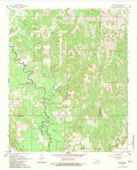
1961 Map of Darwin
USGS Topo · Published 1983About this map
Muddy Boggy Creek meanders heavily through this 1961 landscape, defining the low-lying terrain across the Atoka, Pushmataha, and Choctaw county lines. The northern section of the map centers on the small settlements of Darwin and Old Farris, where local community life is anchored by the Darwin Ch and Center Point Sch. The central and southern portions of the map are dominated by the extensive Mc Leod Honor Farm, which spans several townships along the creek's floodplains. Numerous small oxbow lakes and wetlands, such as Clear Lake, Allen Lake, and Hopena Lake, dot the region, illustrating the active hydrological history of the basin. Further south, the terrain shifts toward more distinct features like Sand Bluff and the drainage of Caney Creek, providing a detailed look at the rural land use and institutional presence in this part of southeastern Oklahoma during the early 1960s.
Find a feature on this map
31 named features on this map. Tap any name to fly to it.
Don’t see what you’re looking for? This feature index may not catch every label — zoom into the map to look around manually.
Map Details
Editions of this 1961 Darwin Map
2 editions found
Other maps of this area

1901 · Antlers
USGS Topo · 1:125,000

1912 · Antlers
USGS Topo · 1:125,000

1925 · Antlers
USGS Topo · 1:125,000

1950 · Mcalester
USGS Topo · 1:250,000

1957 · Farris
USGS Topo · 1:24,000

1957 · Moyers
USGS Topo · 1:24,000

1957 · Lane
USGS Topo · 1:24,000
1961 · Darwin
USGS Topo · 1:24,000

1961 · Antlers West
USGS Topo · 1:24,000

1962 · McAlester
USGS Topo · 1:250,000