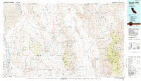
1985 Map of Darwin Hills
USGS Topo · Published 1985About this map
Owens Lake and the high peaks of the Panamint Range anchor this 1985 study of a landscape defined by desert mining and vast military reserves. The map details the transition from the Inyo Mountains across the Panamint Valley to the heights of Death Valley National Monument, featuring Telescope Peak and its surrounding canyons. Economic history is visible in the numerous mining sites like the Modoc Mine and Ophir Mtn Mine, while the southern reaches are dominated by the Naval Weapons Center. Settlement patterns are sparse, ranging from the lakeside community of Keeler to the high-elevation Darwin and the historic Lookout City (Site). Transportation is represented by the Southern Pacific rail line and a network of 4WD trails leading to remote sites like the Anthony Mill Ruins and the iconic Charcoal Kilns near Mahogany Flat.
Find a feature on this map
176 named features on this map. Tap any name to fly to it.
Don’t see what you’re looking for? This feature index may not catch every label — zoom into the map to look around manually.
Map Details
Editions of this 1985 Darwin Hills Map
2 editions found
Other maps of this area

1905 · Olancha
USGS Topo · 1:125,000

1906 · Kernville
USGS Topo · 1:125,000

1907 · Olancha
USGS Topo · 1:125,000

1907 · Mt. Whitney
USGS Topo · 1:125,000

1908 · Furnace Creek
USGS Topo · 1:250,000

1908 · Kernville
USGS Topo · 1:125,000

1908 · Ballarat
USGS Topo · 1:250,000

1910 · Furnace Creek
USGS Topo · 1:250,000

1913 · Ballarat
USGS Topo · 1:250,000

1915 · Searles Lake
USGS Topo · 1:250,000