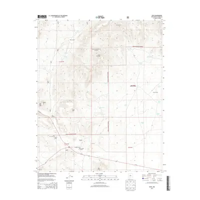
2013 Map of Datil
USGS Topo · Published 2013About this map
Datil stands at the intersection of Us HWY 60 and NM-12, serving as a vital hub in the high-elevation landscape of Catron County. The settlement is anchored by local landmarks such as the Po and the nearby Datil Cem, while the surrounding terrain is defined by the Datil Mountains and the expansive reaches of the Cibola National Forest. The map reveals a land managed for ranching and water conservation, evidenced by numerous named tanks and windmills, including the Government Tank Windmill and Homestead Windmill. From the heights of Indian Peak to the deep incisions of Main Canyon, the geography reflects a history of high-desert navigation. Dispersed homesteads and holdings like Drag A Ranch, Jeffers Place, and Eary Ranch highlight the enduring pattern of rural New Mexico land use, where life follows the drainage of Rincon Draw and Crosby Canyon.
Find a feature on this map
44 named features on this map. Tap any name to fly to it.
Don’t see what you’re looking for? This feature index may not catch every label — zoom into the map to look around manually.
Map Details
Editions of this 2013 Datil Map
This is the sole edition of this map. No revisions or reprints were ever made.
Other maps of this area

1954 · Socorro
USGS Topo · 1:250,000

1958 · Socorro
USGS Topo · 1:250,000

1962 · Socorro
USGS Topo · 1:250,000

1963 · Cal Ship Mesa
USGS Topo · 1:24,000

1963 · Anderson Peak
USGS Topo · 1:24,000

1963 · Datil
USGS Topo · 1:24,000

1964 · Dog Springs
USGS Topo · 1:24,000
1964 · Madre Mountain
USGS Topo · 1:24,000

1964 · Crosby Springs
USGS Topo · 1:24,000
1965 · Sugarloaf Mountain
USGS Topo · 1:24,000