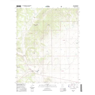
2017 Map of Datil
USGS Topo · Published 2017About this map
Datil stands at the junction of several canyon systems in the southwestern reaches of the Cibola National Forest. The landscape is defined by its arid topography, where prominent heights like Indian Peak and Twin Peaks rise above a series of named draws and water tanks. The settlement of Homestead and the presence of the Datil Cem provide key points of reference for local family history and genealogical research in Catron County. Water management is a primary feature of this terrain, evidenced by numerous basins such as Dean Tank, Clark Tank, and the naturally occurring Hidden Lake to the east. Navigating through Main Canyon and Crosby Canyon, the map illustrates a network of ranching and forest infrastructure developed around these scarce water sources and the dramatic geological formations of the Datil Mountains.
Find a feature on this map
35 named features on this map. Tap any name to fly to it.
Don’t see what you’re looking for? This feature index may not catch every label — zoom into the map to look around manually.
Map Details
Editions of this 2017 Datil Map
This is the sole edition of this map. No revisions or reprints were ever made.
Other maps of this area

1954 · Socorro
USGS Topo · 1:250,000

1958 · Socorro
USGS Topo · 1:250,000

1962 · Socorro
USGS Topo · 1:250,000

1963 · Cal Ship Mesa
USGS Topo · 1:24,000

1963 · Anderson Peak
USGS Topo · 1:24,000

1963 · Datil
USGS Topo · 1:24,000

1964 · Dog Springs
USGS Topo · 1:24,000
1964 · Madre Mountain
USGS Topo · 1:24,000

1964 · Crosby Springs
USGS Topo · 1:24,000
1965 · Sugarloaf Mountain
USGS Topo · 1:24,000