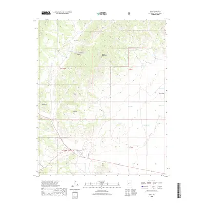
2020 Map of Datil
USGS Topo · Published 2020About this map
The high-altitude terrain of the Datil Mountains dominates this portion of the Cibola National Forest, where the settlement of Datil serves as a small hub at the intersection of local routes. This 2020 survey illustrates a landscape shaped by water management and natural landmarks, including the distinctive Church Rocks and Twin Peaks. The distribution of man-made tanks, such as Dean Tank, Norman Tank, and Rincon Tank, highlights the essential role of water catchment in this arid environment. Genealogy interests are centered around the Datil Cem south of the main settlement area. The map also traces significant geological features like Crosby Canyon, White House Canyon, and Indian Peak, providing a clear view of the drainage patterns and peaks that define the western New Mexico landscape.
Find a feature on this map
32 named features on this map. Tap any name to fly to it.
Don’t see what you’re looking for? This feature index may not catch every label — zoom into the map to look around manually.
Map Details
Editions of this 2020 Datil Map
This is the sole edition of this map. No revisions or reprints were ever made.
Other maps of this area

1954 · Socorro
USGS Topo · 1:250,000

1958 · Socorro
USGS Topo · 1:250,000

1962 · Socorro
USGS Topo · 1:250,000

1963 · Cal Ship Mesa
USGS Topo · 1:24,000

1963 · Anderson Peak
USGS Topo · 1:24,000

1963 · Datil
USGS Topo · 1:24,000

1964 · Dog Springs
USGS Topo · 1:24,000
1964 · Madre Mountain
USGS Topo · 1:24,000

1964 · Crosby Springs
USGS Topo · 1:24,000
1965 · Sugarloaf Mountain
USGS Topo · 1:24,000