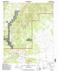
1995 Map of Datil
USGS Topo · Published 1998About this map
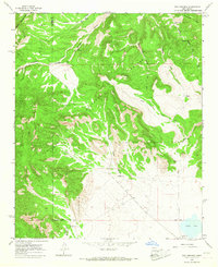
Datil sits at the southern base of the Datil Mountains, serving as a vital crossroads where the drainage of White House Canyon and Crosby Canyon meet. Much of this territory is defined by the Cibola National Forest, where the landscape is etched with deep drainages like Main Canyon and Blue Canyon. The mapping reflects a rugged ranching economy dependent on dispersed water sources, from the Homestead Windmill to specialized improvements like the Electric Well and Cedar Grove Well. Named ranch sites such as the Drag A Ranch and Eary Ranch are positioned near these critical water points, while the Datil Cem provides a genealogical anchor for the community. Evidence of the area's geological and social history is visible in landmarks like Church Rocks and Dead Horse Mesa, alongside small-scale infrastructure like the Landing Area near the town site.
Find a feature on this map
48 named features on this map. Tap any name to fly to it.
Don’t see what you’re looking for? This feature index may not catch every label — zoom into the map to look around manually.
Map Details
Editions of this 1995 Datil Map
This is the sole edition of this map. No revisions or reprints were ever made.
Other maps of this area

1954 · Socorro
USGS Topo · 1:250,000

1958 · Socorro
USGS Topo · 1:250,000

1962 · Socorro
USGS Topo · 1:250,000
1963 · Cal Ship Mesa
USGS Topo · 1:24,000
1963 · Anderson Peak
USGS Topo · 1:24,000
1963 · Datil
USGS Topo · 1:24,000
1964 · Dog Springs
USGS Topo · 1:24,000
1964 · Madre Mountain
USGS Topo · 1:24,000
1964 · Crosby Springs
USGS Topo · 1:24,000
1965 · Sugarloaf Mountain
USGS Topo · 1:24,000