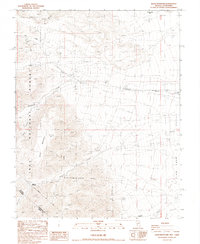
1987 Map of Davis Mountain
USGS Topo · Published 1987About this map
Davis Mountain dominates this rugged high-altitude landscape along the border of Nevada and California. The map documents a transition from the steep eastern slopes of the Inyo National Forest down into the northern reaches of Fish Lake Valley. Early industrial and exploration efforts are evidenced by the Red Rock Mine in the northwest and the Mollini Mine Prospect further south, alongside numerous unnamed prospects. Water management and natural springs are vital in this arid environment, marked by a Gaging Station on Chiatovich Creek and several isolated Springs. Small settlements like McNett and Post Meadow sit near the historic Von Schmidt Line, representing the sparse but persistent human footprint in this remote region during the late twentieth century.
Find a feature on this map
25 named features on this map. Tap any name to fly to it.
Don’t see what you’re looking for? This feature index may not catch every label — zoom into the map to look around manually.
Map Details
Editions of this 1987 Davis Mountain Map
2 editions found
Other maps of this area

1917 · White Mountain
USGS Topo · 1:125,000

1947 · Mariposa
USGS Topo · 1:250,000

1948 · Mariposa
USGS Topo · 1:250,000

1957 · Mariposa
USGS Topo · 1:250,000

1962 · Benton
USGS Topo · 1:62,500

1962 · Mt. Barcroft
USGS Topo · 1:62,500

1962 · White Mtn. Peak
USGS Topo · 1:62,500

1963 · Mariposa
USGS Topo · 1:250,000

1963 · Davis Mountain
USGS Topo · 1:62,500
1987 · Volcanic Hills West
USGS Topo · 1:24,000