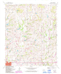
1965 Map of Davis
USGS Topo · Published 1993About this map
The town of Davis sits at the southern edge of this Oklahoma survey, marked by its Post Office and High School, while the northern reaches of the Chickasaw National Recreation Area and the Lake of the Arbuckles dominate the southeast. The landscape is defined by its industrial activity, notably the Northern Davis Oil Field, Northwest Sulphur Oil Field, and several scattered quarries. Small rural centers like Chigley and Iona are visible among the drainage networks of Sandy Creek and Kickapoo Creek. Traces of earlier infrastructure appear through the old railroad grade winding through the terrain, while local genealogy is rooted in sites like Sandy Church and a hilltop cemetery. This 1965 map, later updated in the 1990s, documents the shift from traditional ranching and rail to a modern landscape of petroleum extraction and federal recreation land.
Find a feature on this map
30 named features on this map. Tap any name to fly to it.
Don’t see what you’re looking for? This feature index may not catch every label — zoom into the map to look around manually.
Map Details
Editions of this 1965 Davis Map
2 editions found

Other maps of this area

1898 · Pauls Valley
USGS Topo · 1:125,000

1901 · Stonewall
USGS Topo · 1:125,000

1901 · Tishomingo
USGS Topo · 1:125,000

1901 · Ardmore
USGS Topo · 1:125,000

1902 · Pauls Valley
USGS Topo · 1:125,000

1918 · Ardmore
USGS Topo · 1:125,000

1957 · Ardmore
USGS Topo · 1:250,000

1963 · Ardmore
USGS Topo · 1:250,000

1963 · Sulphur South
USGS Topo · 1:24,000

1964 · Turner Falls
USGS Topo · 1:24,000