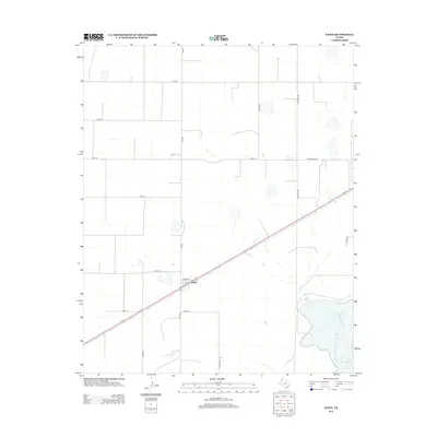
2012 Map of Dawn
USGS Topo · Published 2012About this map
Dawn sits at the intersection of several significant agricultural corridors in Deaf Smith County, reflecting the deep-rooted ranching and farming heritage of the Texas Panhandle. The settlement is centered along the path of Us-60 and Fm-809, forming a vital junction for the transport of goods across the High Plains. To the southeast, the landscape is defined by the winding course of Tierra Blanca Cr, a critical water source that historically supported the regional cattle industry. The map reveals a strictly organized grid of rural roads, including Pondaseta Rd and Alines Rd, which delineate large tracts of productive land. This layout underscores the transition of the region from open range to a highly structured landscape of modern irrigated agriculture and livestock operations during the early 21st century.
Find a feature on this map
18 named features on this map. Tap any name to fly to it.
Don’t see what you’re looking for? This feature index may not catch every label — zoom into the map to look around manually.
Map Details
Editions of this 2012 Dawn Map
This is the sole edition of this map. No revisions or reprints were ever made.
Other maps of this area

1954 · Tucumcari
USGS Topo · 1:250,000

1954 · Clovis
USGS Topo · 1:250,000

1958 · Clovis
USGS Topo · 1:250,000

1958 · Tucumcari
USGS Topo · 1:250,000

1961 · Buffalo Lake
USGS Topo · 1:62,500

1962 · Wildorado
USGS Topo · 1:62,500

1965 · Allison Ranch
USGS Topo · 1:24,000

1971 · Hereford NE
USGS Topo · 1:24,000

1971 · Hereford SE
USGS Topo · 1:24,000
1984 · Bivins Lake
USGS Topo · 1:24,000