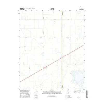
2016 Map of Dawn
USGS Topo · Published 2016About this map
Dawn sits at the center of this landscape in the Texas Panhandle, positioned along a major diagonal transportation corridor. The settlement is surrounded by a network of rural roads that follow a strict section-line grid, including Ranch Rd 1062, Church Rd, and Westline Rd. This geometry of the High Plains is briefly interrupted in the southeast by the depression of Buffalo Lake, where the flat terrain gives way to the beginning of more varied contours. The map also delineates the jurisdictional boundary between Deaf Smith Co and Randall Co, providing a clear look at how land management and transportation like Fm 1062 and Westgate are organized across this agricultural region during the mid-2010s.
Find a feature on this map
17 named features on this map. Tap any name to fly to it.
Don’t see what you’re looking for? This feature index may not catch every label — zoom into the map to look around manually.
Map Details
Editions of this 2016 Dawn Map
This is the sole edition of this map. No revisions or reprints were ever made.
Other maps of this area

1954 · Tucumcari
USGS Topo · 1:250,000

1954 · Clovis
USGS Topo · 1:250,000

1958 · Clovis
USGS Topo · 1:250,000

1958 · Tucumcari
USGS Topo · 1:250,000

1961 · Buffalo Lake
USGS Topo · 1:62,500

1962 · Wildorado
USGS Topo · 1:62,500

1965 · Allison Ranch
USGS Topo · 1:24,000

1971 · Hereford NE
USGS Topo · 1:24,000

1971 · Hereford SE
USGS Topo · 1:24,000
1984 · Bivins Lake
USGS Topo · 1:24,000