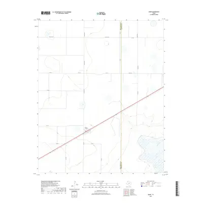
2019 Map of Dawn
USGS Topo · Published 2019About this map
Dawn serves as the primary settlement on this High Plains landscape, situated along a straight rail line that cuts diagonally through the southern half of the quadrangle. The community features a Po and a surrounding network of county roads that reflect the area's agricultural layout, including Church Rd and Ranch Rd 809. The terrain is characterized by subtle elevation changes and numerous depressions typical of the Llano Estacado. In the southeast, Tierra Blanca Cr provides a natural break in the geometric grid of farm-to-market and county roads. The boundary between Deaf Smith Co and Randall Co runs vertically through the eastern portion of the sheet, dividing these two Texas Panhandle counties.
Find a feature on this map
18 named features on this map. Tap any name to fly to it.
Don’t see what you’re looking for? This feature index may not catch every label — zoom into the map to look around manually.
Map Details
Editions of this 2019 Dawn Map
This is the sole edition of this map. No revisions or reprints were ever made.
Other maps of this area

1954 · Tucumcari
USGS Topo · 1:250,000

1954 · Clovis
USGS Topo · 1:250,000

1958 · Clovis
USGS Topo · 1:250,000

1958 · Tucumcari
USGS Topo · 1:250,000

1961 · Buffalo Lake
USGS Topo · 1:62,500

1962 · Wildorado
USGS Topo · 1:62,500

1965 · Allison Ranch
USGS Topo · 1:24,000

1971 · Hereford NE
USGS Topo · 1:24,000

1971 · Hereford SE
USGS Topo · 1:24,000
1984 · Bivins Lake
USGS Topo · 1:24,000