
2022 Map of Dawn
USGS Topo · Published 2022About this map
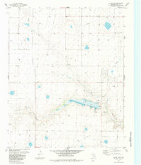
Dawn serves as the primary focal point of this High Plains landscape, situated along a diagonal transit corridor that bisects the rectangular grid of the Texas Panhandle. The settlement is anchored by a network of rural routes, including Ranch Rd 809 and Ranch Rd 1062, which reflect the region's agricultural and ranching infrastructure. The terrain is characterized by large open tracts and a series of depressions that collect seasonal moisture, typical of the Llano Estacado.
Find a feature on this map
16 named features on this map. Tap any name to fly to it.
Don’t see what you’re looking for? This feature index may not catch every label — zoom into the map to look around manually.
Map Details
Editions of this 2022 Dawn Map
This is the sole edition of this map. No revisions or reprints were ever made.
Other maps of this area

1954 · Tucumcari
USGS Topo · 1:250,000

1954 · Clovis
USGS Topo · 1:250,000

1958 · Clovis
USGS Topo · 1:250,000

1958 · Tucumcari
USGS Topo · 1:250,000

1961 · Buffalo Lake
USGS Topo · 1:62,500

1962 · Wildorado
USGS Topo · 1:62,500

1965 · Allison Ranch
USGS Topo · 1:24,000

1971 · Hereford NE
USGS Topo · 1:24,000

1971 · Hereford SE
USGS Topo · 1:24,000
1984 · Bivins Lake
USGS Topo · 1:24,000