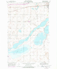
1952 Map of Dawson
USGS Topo · Published 1978About this map
Dawson serves as the focal point for this survey of the North Dakota prairie, situated along the Burlington Northern railroad corridor. The landscape is defined by its substantial glacial lakes, including the sprawling Alkaline Lake and Manning Lake to the south, which are framed by the higher ground of Woodlawn and Sibley. These topographical features reflect the terminal moraine geography of the region, where water naturally pools in low-lying basins. The rural character of the era is evidenced by the solitary Liberty Sch located in the southern portion of the quadrangle, illustrating the decentralized educational system of mid-century North Dakota. Compiled from 1951 aerial photography and 1952 field surveys, with 1975 purple revisions, this map captures the essential transport and water management patterns overseen by the State of North Dakota Water Conservation Commission.
Find a feature on this map
8 named features on this map. Tap any name to fly to it.
Don’t see what you’re looking for? This feature index may not catch every label — zoom into the map to look around manually.
Map Details
Editions of this 1952 Dawson Map
2 editions found
Other maps of this area

1952 · Tappen South
USGS Topo · 1:24,000

1952 · Dawson
USGS Topo · 1:24,000

1952 · Tappen North
USGS Topo · 1:24,000

1952 · Steele NE
USGS Topo · 1:24,000

1952 · Steele
USGS Topo · 1:24,000

1952 · Steele NW
USGS Topo · 1:24,000

1953 · Jamestown
USGS Topo · 1:250,000

1956 · Jamestown
USGS Topo · 1:250,000
1975 · Tappen North
USGS Topo · 1:24,000

1979 · Kintyre NE
USGS Topo · 1:24,000