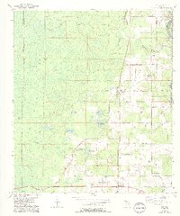
1954 Map of Day
USGS Topo · Published 1993About this map
San Pedro Bay dominates the western half of this Florida landscape, characterized by a complex network of wetlands and ponds including Grassy Pond and Tiger Bay. The eastern section shows a shift toward rural settlement patterns near the Suwannee River boundary, centered around the community of Day. The presence of several Old Grade railroad alignments and stops like Mayo Junction and Townsend illustrates the importance of timber and agricultural transport in Lafayette County during the mid-20th century. Local family history is preserved through markers such as Roger Cem and Dees Cem, alongside spiritual centers like Magnolia Ch and Riverside Ch. This survey, compiled from 1951 aerial photography, provides a detailed view of the drainage patterns from Fort Atkinson Lake to Bell Lake before modern development altered the hydraulic character of the region.
Find a feature on this map
26 named features on this map. Tap any name to fly to it.
Don’t see what you’re looking for? This feature index may not catch every label — zoom into the map to look around manually.
Map Details
Editions of this 1954 Day Map
3 editions found
Other maps of this area

1954 · Fenholloway
USGS Topo · 1:24,000

1954 · Day SE
USGS Topo · 1:24,000

1954 · Day
USGS Topo · 1:24,000

1954 · Dowling Park
USGS Topo · 1:24,000

1954 · Day NW
USGS Topo · 1:24,000

1954 · Valdosta
USGS Topo · 1:250,000

1955 · Mayo
USGS Topo · 1:24,000

1958 · Valdosta
USGS Topo · 1:250,000

1958 · Madison SW
USGS Topo · 1:24,000

1958 · Madison SE
USGS Topo · 1:24,000