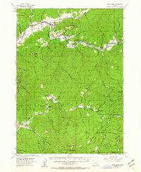
1954 Map of Days Creek
USGS Topo · Published 1963About this map
The South Fork Umpqua River and Cow Creek form the primary drainage systems for this mountainous region of southern Oregon during the mid-1950s. The settlement at Days Creek serves as a local hub near the Bland Min Cemetery and Lavadoure Community Hall, while further east along the river lie the communities of Milo and Academy. This survey captures the rural infrastructure of the era, featuring remote educational outposts like Galesville School and Anchor School, and the operational presence of the Devils Flat Guard Sta within the Umpqua National Forest. Timber and resource management are evident through the network of trails and pack trails crossing Hyde Ridge and Patrick Mtn. The landscape is also defined by the Cow Creek Game Refuge and smaller industrial sites like the Miller Mine on Fate Creek.
Find a feature on this map
57 named features on this map. Tap any name to fly to it.
Don’t see what you’re looking for? This feature index may not catch every label — zoom into the map to look around manually.
Map Details
Editions of this 1954 Days Creek Map
3 editions found
Other maps of this area

1891 · Ashland
USGS Topo · 1:250,000

1893 · Ashland
USGS Topo · 1:250,000

1897 · Roseburg
USGS Topo · 1:125,000

1897 · Ashland
USGS Topo · 1:250,000

1900 · Roseburg
USGS Topo · 1:125,000

1904 · Riddle
USGS Topo · 1:125,000

1943 · Trail
USGS Topo · 1:62,500

1944 · Tiller
USGS Topo · 1:62,500

1954 · Dixonville
USGS Topo · 1:62,500

1954 · Days Creek
USGS Topo · 1:62,500