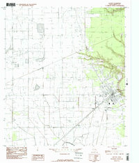
1984 Map of Dayton
USGS Topo · Published 1985About this map
Dayton serves as the primary hub of activity in this part of Liberty County, showing a concentration of street grids and rail infrastructure during the mid-1970s and early 1980s. The landscape transitioning west of the town is defined by industrial and agricultural development, marked by the extensive Dayton Canal and various oil fields. Small outlying settlements like Stilson, Martha, and Gum Grove provide a glimpse into the rural community structure that supported the regional economy before later suburban expansion.
Find a feature on this map
9 named features on this map. Tap any name to fly to it.
Don’t see what you’re looking for? This feature index may not catch every label — zoom into the map to look around manually.
Map Details
Editions of this 1984 Dayton Map
2 editions found
Other maps of this area

1916 · Crosby
USGS Topo · 1:24,000

1916 · Huffman
USGS Topo · 1:24,000

1919 · Crosby
USGS Topo · 1:31,680

1920 · Huffman
USGS Topo · 1:31,680

1943 · Liberty
USGS Topo · 1:125,000
1944 · Crosby
USGS Topo · 1:31,680

1950 · Houston
USGS Topo · 1:250,000
1954 · Crosby
USGS Topo · 1:24,000

1954 · Beaumont
USGS Topo · 1:250,000

1955 · Liberty
USGS Topo · 1:62,500