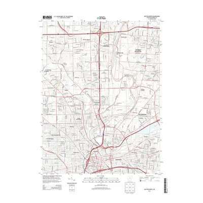
2013 Map of Dayton North
USGS Topo · Published 2013About this map
Dayton and its northern suburbs are defined by the convergence of the Great Miami River, Stillwater River, and Mad River. This modern topographic survey illustrates the dense residential and industrial footprint of the city, including neighborhoods such as Riverdale, Northridge, and Fairview. The transportation network is dominated by the junction of Interstate 70 and Interstate 75, which carved through established areas like Vandalia and Murlin Heights. Genealogy researchers will find numerous small burial grounds and landmarks preserved in the suburban landscape, from the Friends Cem and Shiloh Cem to the unique Narrows Pet Cem along the Stillwater River. Educational and community hubs like the Sinclair Community Coll and Dayton Memorial Park serve as fixed points of reference within the expanding urban sprawl of Huber Heights and Riverside.
Find a feature on this map
56 named features on this map. Tap any name to fly to it.
Don’t see what you’re looking for? This feature index may not catch every label — zoom into the map to look around manually.
Map Details
Editions of this 2013 Dayton North Map
This is the sole edition of this map. No revisions or reprints were ever made.
Other maps of this area

1904 · Dayton
USGS Topo · 1:62,500

1905 · Brookville
USGS Topo · 1:62,500

1906 · Dayton
USGS Topo · 1:62,500

1908 · Miamisburg
USGS Topo · 1:62,500

1913 · Waynesville
USGS Topo · 1:62,500

1915 · Waynesville
USGS Topo · 1:62,500

1953 · Cincinnati
USGS Topo · 1:250,000

1955 · Miamisburg
USGS Topo · 1:24,000

1955 · Dayton South
USGS Topo · 1:24,000
1955 · Bellbrook
USGS Topo · 1:24,000