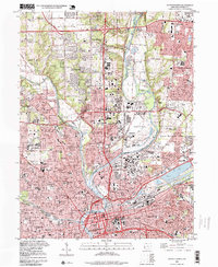
1996 Map of Dayton North
USGS Topo · Published 1999About this map
The confluence of the Great Miami River, Stillwater River, and Mad River anchors this detailed look at northern Dayton during the late 1990s. The landscape reflects a dense urban and suburban concentration, characterized by a series of major highway interchanges and established neighborhoods like Shiloh, Northridge, and Huber Heights. Key civic landmarks including the Courthouse, City Safety Bldg, and Sinclair College define the city's downtown core, while the eastern edge is dominated by the sprawling grounds of Wright-Patterson Air Force Base.
Find a feature on this map
61 named features on this map. Tap any name to fly to it.
Don’t see what you’re looking for? This feature index may not catch every label — zoom into the map to look around manually.
Map Details
Editions of this 1996 Dayton North Map
This is the sole edition of this map. No revisions or reprints were ever made.
Other maps of this area

1904 · Dayton
USGS Topo · 1:62,500

1905 · Brookville
USGS Topo · 1:62,500

1906 · Dayton
USGS Topo · 1:62,500

1908 · Miamisburg
USGS Topo · 1:62,500

1913 · Waynesville
USGS Topo · 1:62,500

1915 · Waynesville
USGS Topo · 1:62,500

1953 · Cincinnati
USGS Topo · 1:250,000

1955 · Miamisburg
USGS Topo · 1:24,000

1955 · Dayton South
USGS Topo · 1:24,000
1955 · Bellbrook
USGS Topo · 1:24,000