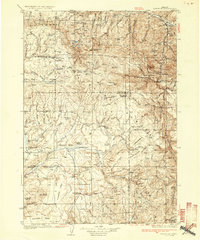
1936 Map of Dayville
USGS Topo · Published 1936About this map
The John Day River flows through the northeast corner of this central Oregon landscape, where the town of Dayville sits at the junction of valley and upland terrain. Surveyed in the early 1930s, the map documents a remote ranching and timber economy centered around the high plateaus of Ryegrass Table, Shaw Table, and Twelvemile Table. Settlement patterns follow the water, with cattle and sheep operations like the Claypool Ranch and Mills Ranch established near the drainages of Beaver Creek and the Paulina Valley.
Find a feature on this map
123 named features on this map. Tap any name to fly to it.
Don’t see what you’re looking for? This feature index may not catch every label — zoom into the map to look around manually.
Map Details
Editions of this 1936 Dayville Map
3 editions found
Other maps of this area

1926 · Mitchell
USGS Topo · 1:125,000

1932 · Dayville
USGS Topo · 1:125,000

1936 · Dayville
USGS Topo · 1:125,000

1940 · Aldrich Mtn.
USGS Topo · 1:62,500

1943 · Aldrich Mtn.
USGS Topo · 1:62,500

1951 · Courtrock
USGS Topo · 1:62,500

1953 · Richmond
USGS Topo · 1:62,500

1953 · Picture
USGS Topo · 1:62,500

1955 · Crescent
USGS Topo · 1:250,000

1955 · Bend
USGS Topo · 1:250,000