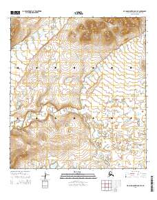
2015 Map of De Long Mountains A-4 SE
USGS Topo · Published 2015About this map
Sapumegrak Mtn dominates the northern horizon of this Arctic landscape, where high-elevation terrain gives way to a network of hydrologic features and valleys. The elevation contours reveal a descent from these peaks toward the Nadviktak Lakes in the south, suggesting a drainage pattern typical of the Brooks Range foothills. In the southwest, the Aupilatuk Hills rise as a secondary upland formation, creating a diverse topographical profile across the region. This 2015 survey by the U.S. Geological Survey utilizes satellite imagery and national hydrography data to delineate the precise boundaries and natural flow of this remote territory, providing an essential record of the surface features before potential environmental or climatic shifts alter the permafrost-influenced terrain.
Find a feature on this map
12 named features on this map. Tap any name to fly to it.
Don’t see what you’re looking for? This feature index may not catch every label — zoom into the map to look around manually.
Map Details
Editions of this 2015 De Long Mountains A-4 SE Map
This is the sole edition of this map. No revisions or reprints were ever made.
Other maps of this area

1951 · De Long Mountains
USGS Topo · 1:250,000

1951 · Noatak
USGS Topo · 1:250,000

1955 · Noatak
USGS Topo · 1:250,000

1955 · De Long Mountains
USGS Topo · 1:250,000

1955 · Noatak D-4
USGS Topo · 1:63,360

1955 · De Long Mountains A-3
USGS Topo · 1:63,360

1955 · De Long Mountains A-4
USGS Topo · 1:63,360
1955 · Noatak D-5
USGS Topo · 1:63,360

1964 · Noatak
USGS Topo · 1:250,000

1965 · De Long Mountains
USGS Topo · 1:250,000