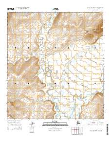
2014 Map of De Long Mountains A-4 SW
USGS Topo · Published 2014About this map
The Kivalina River meanders through this portion of the De Long Mountains, defining the central drainage of a landscape marked by high elevations and prominent lookouts. The terrain is anchored by the significant height of Sapumegrak Mountain in the northeast and Inukpasuk Hill to the north, which dominate the local topography. This 2014 survey by the U.S. Geological Survey captures the area's geography during a period of modern topographical mapping, utilizing North American Datum of 1983 standards. The presence of Kawiksak Bluff overlooking the river valley highlights a region defined by its natural watercourses and dramatic relief. This map is particularly useful for understanding the hydrological patterns of the Northwest Arctic Borough and identifying family-named or culturally significant landmarks in this remote Arctic terrain.
Find a feature on this map
10 named features on this map. Tap any name to fly to it.
Don’t see what you’re looking for? This feature index may not catch every label — zoom into the map to look around manually.
Map Details
Editions of this 2014 De Long Mountains A-4 SW Map
This is the sole edition of this map. No revisions or reprints were ever made.
Other maps of this area

1951 · De Long Mountains
USGS Topo · 1:250,000

1951 · Noatak
USGS Topo · 1:250,000

1955 · Noatak
USGS Topo · 1:250,000

1955 · De Long Mountains
USGS Topo · 1:250,000

1955 · De Long Mountains A-4
USGS Topo · 1:63,360
1955 · Noatak D-5
USGS Topo · 1:63,360
1955 · De Long Mountains A-5
USGS Topo · 1:63,360

1964 · Noatak
USGS Topo · 1:250,000

1965 · De Long Mountains
USGS Topo · 1:250,000
2014 · De Long Mountains A-5 NE
USGS Topo · 1:25,000