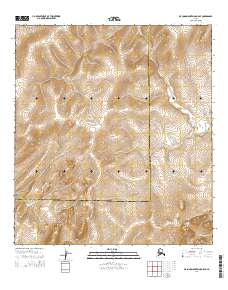
2014 Map of De Long Mountains A-5 SE
USGS Topo · Published 2014About this map
The Singoalik River flows through the southern reaches of this remote terrain, providing a primary drainage feature in a landscape defined by significant elevation changes. This 2014 survey documents a quiet boundary between the North Slope Borough and the Northwest Arctic Borough, which cuts across the lower third of the map. Aside from these administrative lines and the waterway, the area remains largely devoid of modern development, showing the natural state of the De Long Mountains area. Local topography is recorded through fine contour intervals, tracing the ridges and valleys that separate the river drainage from the high ground to the north, offering a clear view of the land's form without the interference of man-made structures.
Find a feature on this map
8 named features on this map. Tap any name to fly to it.
Don’t see what you’re looking for? This feature index may not catch every label — zoom into the map to look around manually.
Map Details
Editions of this 2014 De Long Mountains A-5 SE Map
This is the sole edition of this map. No revisions or reprints were ever made.
Other maps of this area

1951 · De Long Mountains
USGS Topo · 1:250,000

1951 · Noatak
USGS Topo · 1:250,000

1955 · Noatak
USGS Topo · 1:250,000

1955 · De Long Mountains
USGS Topo · 1:250,000

1955 · De Long Mountains A-4
USGS Topo · 1:63,360
1955 · Noatak D-6
USGS Topo · 1:63,360
1955 · Noatak D-5
USGS Topo · 1:63,360
1955 · De Long Mountains A-5
USGS Topo · 1:63,360

1964 · Noatak
USGS Topo · 1:250,000

1965 · De Long Mountains
USGS Topo · 1:250,000