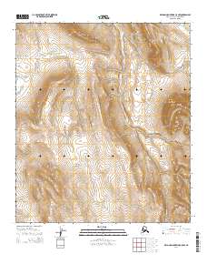
2014 Map of De Long Mountains C-5 NW
USGS Topo · Published 2014About this map
The Nimi River and Thetis Cr carve through this remote section of the De Long Mountains within the North Slope Borough. This 2014 survey focuses on the intricate drainage patterns of the western Arctic, where the landscape is defined by the sharp topographical rise into the De Long range. The map documents the hydrography of the region in fine detail, tracing the headwaters and tributaries that form the seasonal watercourses of the high latitudes. The Public Land Survey System grid, including t8s r55w and t9s r56w, provides the primary spatial reference for this uninhabited terrain, capturing the area as it remained a frontier of geological and hydrological study in the early 21st century.
Find a feature on this map
6 named features on this map. Tap any name to fly to it.
Don’t see what you’re looking for? This feature index may not catch every label — zoom into the map to look around manually.
Map Details
Editions of this 2014 De Long Mountains C-5 NW Map
This is the sole edition of this map. No revisions or reprints were ever made.
Other maps of this area

1951 · De Long Mountains
USGS Topo · 1:250,000

1952 · Point Hope
USGS Topo · 1:250,000

1952 · Point Hope D-1
USGS Topo · 1:63,360

1955 · De Long Mountains
USGS Topo · 1:250,000

1955 · Point Hope
USGS Topo · 1:250,000

1955 · Point Hope C-1
USGS Topo · 1:63,360

1955 · De Long Mountains C-5
USGS Topo · 1:63,360
1955 · De Long Mountains D-5
USGS Topo · 1:63,360

1965 · Point Hope
USGS Topo · 1:250,000

1965 · De Long Mountains
USGS Topo · 1:250,000