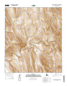
2014 Map of De Long Mountains C-5 SW
USGS Topo · Published 2014About this map
Ipewik River snakes across this high-latitude terrain, carving a deep valley through the northern landscape of the De Long Mountains. The topography is dominated by dramatic elevation changes, notably the prominent Becket Ridge which rises in the eastern portion of the quadrangle. Smaller tributaries like Thetis Cr feed into the regional drainage system, illustrating the watershed patterns of the North Slope. Surveyed in the early 21st century by the U.S. Geological Survey, this sheet captures a wilderness area defined by its natural hydrology and relief rather than human settlement. The map provides precise detail on the drainage basins and ridgelines that characterize this portion of the Alaska-North Slope Borough.
Find a feature on this map
9 named features on this map. Tap any name to fly to it.
Don’t see what you’re looking for? This feature index may not catch every label — zoom into the map to look around manually.
Map Details
Editions of this 2014 De Long Mountains C-5 SW Map
This is the sole edition of this map. No revisions or reprints were ever made.
Other maps of this area

1951 · De Long Mountains
USGS Topo · 1:250,000

1952 · Point Hope
USGS Topo · 1:250,000

1955 · De Long Mountains
USGS Topo · 1:250,000

1955 · Point Hope
USGS Topo · 1:250,000

1955 · Point Hope C-1
USGS Topo · 1:63,360

1955 · Point Hope B-1
USGS Topo · 1:63,360

1955 · De Long Mountains C-5
USGS Topo · 1:63,360
1955 · De Long Mountains B-5
USGS Topo · 1:63,360

1965 · Point Hope
USGS Topo · 1:250,000

1965 · De Long Mountains
USGS Topo · 1:250,000