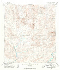
1955 Map of De Long Mountains B-5
USGS Topo · Published 1971About this map
The Kukpuk River snakes through the southeastern reaches of this remote Alaskan wilderness, its path carved into the drainage patterns of the De Long Mountains. Produced from 1952 aerial photography and 1955 field annotations, the map reveals a largely uninhabited landscape defined by tight contour intervals and significant elevation changes. The land lines shown here represent unsurveyed and unmarked locations predetermined by the Bureau of Land Management under the Umiat and Kateel River Meridians, highlighting the frontier status of the North Slope during the mid-20th century. This area is characterized by high alpine terrain and numerous unnamed drainage basins that feed into the primary river system, reflecting the untouched character of the region before significant modern development.
Find a feature on this map
2 named features on this map. Tap any name to fly to it.
Don’t see what you’re looking for? This feature index may not catch every label — zoom into the map to look around manually.
Map Details
Editions of this 1955 De Long Mountains B-5 Map
This is the sole edition of this map. No revisions or reprints were ever made.
Other maps of this area

1951 · De Long Mountains
USGS Topo · 1:250,000

1952 · Point Hope
USGS Topo · 1:250,000

1955 · De Long Mountains
USGS Topo · 1:250,000

1955 · Point Hope
USGS Topo · 1:250,000

1955 · Point Hope C-1
USGS Topo · 1:63,360

1955 · Point Hope A-1
USGS Topo · 1:63,360

1955 · Point Hope B-1
USGS Topo · 1:63,360

1955 · De Long Mountains A-4
USGS Topo · 1:63,360
1955 · De Long Mountains A-5
USGS Topo · 1:63,360

1955 · De Long Mountains C-4
USGS Topo · 1:63,360