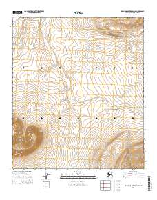
2015 Map of De Long Mountains D-2 SE
USGS Topo · Published 2015About this map
Igloo Mtn dominates the southwestern corner of this Arctic landscape, its steep contours rising sharply above the surrounding drainages. This 2015 survey of the North Slope captures a remote wilderness defined by the winding course of Surprise Cr, which flows through the central valley across several township boundaries including t7s r46w and t7s r45w. The map illustrates a vast, uninhabited terrain where the natural topography dictates the character of the land. Researchers can trace the intricate stream networks and elevation changes that define this sub-arctic environment, providing a clear view of the physical geography before any significant human development or infrastructure was established in this specific sector of the De Long Mountains.
Find a feature on this map
8 named features on this map. Tap any name to fly to it.
Don’t see what you’re looking for? This feature index may not catch every label — zoom into the map to look around manually.
Map Details
Editions of this 2015 De Long Mountains D-2 SE Map
This is the sole edition of this map. No revisions or reprints were ever made.
Other maps of this area

1951 · De Long Mountains
USGS Topo · 1:250,000

1955 · De Long Mountains
USGS Topo · 1:250,000

1955 · De Long Mountains D-2
USGS Topo · 1:63,360
1955 · De Long Mountains D-1
USGS Topo · 1:63,360
1955 · De Long Mountains C-2
USGS Topo · 1:63,360
1955 · De Long Mountains C-1
USGS Topo · 1:63,360

1965 · De Long Mountains
USGS Topo · 1:250,000
2014 · De Long Mountains D-2 NE
USGS Topo · 1:25,000
2014 · De Long Mountains D-2 NW
USGS Topo · 1:25,000
2014 · De Long Mountains D-2 SW
USGS Topo · 1:25,000