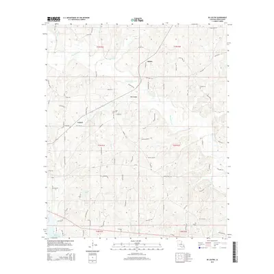
2015 Map of De Loutre
USGS Topo · Published 2015About this map
Bayou de Loutre meanders through this portion of Union Parish, defining a landscape shaped by narrow creek valleys and local landholdings. Small settlements such as De Loutre and Canbeal serve as focal points for a network of rural roads, including the notable De Loutre Switch Rd, suggesting the historical presence of rail-based transport in the timber or agricultural sectors. Genealogists will find several family and community burial sites scattered across the terrain, including Edwards Cem in the east and Antioch Cem to the south. The southern edge of the map is dominated by the waters of Bayou D'Arbonne Lake, which contrasts with the smaller water bodies like Ouchleys Pond. This survey provides a modern view of traditional Louisiana parish life, where the geography of named creeks like Big Cane Cr and Horse Pen Cr continues to dictate local boundaries.
Find a feature on this map
92 named features on this map. Tap any name to fly to it.
Don’t see what you’re looking for? This feature index may not catch every label — zoom into the map to look around manually.
Map Details
Editions of this 2015 De Loutre Map
This is the sole edition of this map. No revisions or reprints were ever made.
Other maps of this area

1935 · Drew
USGS Topo · 1:62,500

1935 · Haile
USGS Topo · 1:62,500

1952 · Calhoun
USGS Topo · 1:62,500

1952 · Farmerville
USGS Topo · 1:62,500

1955 · Shreveport
USGS Topo · 1:250,000

1956 · Shreveport
USGS Topo · 1:250,000

1956 · Haile
USGS Topo · 1:62,500

1957 · Monroe North
USGS Topo · 1:62,500
1969 · Monroe North
USGS Topo · 1:62,500
1982 · Point
USGS Topo · 1:24,000