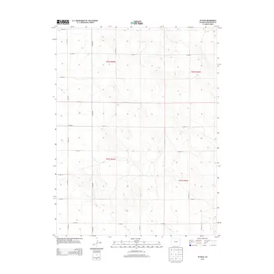
2013 Map of De Nova
USGS Topo · Published 2013About this map
Jack Cr flows through the northwestern corner of this landscape in Washington County, marking one of the few natural hydrographic features in an area dominated by the rigid geometry of the Public Land Survey System. The terrain is defined by a consistent grid of county thoroughfares, including Co Road RR and Co Road 17, which carve the high plains into precise sections. This 2013 survey illustrates the enduring rural structure of the De Nova area, where the road network follows township and range lines such as t002s r050w and t003s r049w. The map reflects a modern era of land management, using data from the National Elevation Dataset and the Bureau of Land Management to document the subtle contours and vast agricultural divisions characteristic of eastern Colorado.
Find a feature on this map
21 named features on this map. Tap any name to fly to it.
Don’t see what you’re looking for? This feature index may not catch every label — zoom into the map to look around manually.
Map Details
Editions of this 2013 De Nova Map
This is the sole edition of this map. No revisions or reprints were ever made.
Other maps of this area

1954 · Limon
USGS Topo · 1:250,000

1957 · Limon
USGS Topo · 1:250,000

1958 · Limon
USGS Topo · 1:250,000

1974 · De Nova SE
USGS Topo · 1:24,000
1974 · De Nova NE
USGS Topo · 1:24,000
1974 · De Nova NW
USGS Topo · 1:24,000

1977 · Cope
USGS Topo · 1:24,000

1977 · Arickaree
USGS Topo · 1:24,000
1977 · Elba NE
USGS Topo · 1:24,000

1977 · Elba SE
USGS Topo · 1:24,000