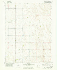
1974 Map of De Nova NW
USGS Topo · Published 1978About this map
Jack Creek carves a subtle path through the eastern plains of Washington County, defining the primary drainage for this stretch of open prairie. Mapping from the 1970s reveals a landscape organized around dryland agriculture and resource extraction, punctuated by numerous isolated Wells and several Storage Bins used for grain storage. The topographic detail indicates a pattern of section lines and range roads that dictate the movement across the terrain, reflecting the rigid grid system of the western homestead era. Small-scale industrial activity is evident at the Gravel Pit near the southern edge of the sheet, providing insight into local material sourcing during this period of rural development.
Find a feature on this map
5 named features on this map. Tap any name to fly to it.
Don’t see what you’re looking for? This feature index may not catch every label — zoom into the map to look around manually.
Map Details
Editions of this 1974 De Nova NW Map
2 editions found
Other maps of this area

1954 · Limon
USGS Topo · 1:250,000

1954 · Sterling
USGS Topo · 1:250,000

1957 · Limon
USGS Topo · 1:250,000

1958 · Limon
USGS Topo · 1:250,000

1958 · Sterling
USGS Topo · 1:250,000

1972 · Snyder Lake
USGS Topo · 1:24,000

1972 · Otis SE
USGS Topo · 1:24,000

1973 · Akron SE
USGS Topo · 1:24,000

1974 · De Nova SE
USGS Topo · 1:24,000
1974 · De Nova NE
USGS Topo · 1:24,000