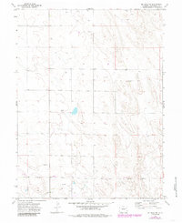
1974 Map of De Nova NW
USGS Topo · Published 1985About this map
Jack Creek meanders through this agricultural section of Washington County, defining the drainage patterns of the high plains landscape. Surveyed in the mid-1970s and revised in the early 1980s, the map reveals an environment shaped by water management and resource extraction, punctuated by numerous Wells scattered across the township grid. Infrastructure for regional agriculture is evident through landmarks such as Storage Bins and a Pumping Sta, which indicate the localized storage and transport needs of the era. The presence of a Pipeline cutting through the southern portion of the quadrangle and a Gravel Pit near the creek suggest a landscape integrated into broader industrial and transportation networks beyond just surface farming.
Find a feature on this map
8 named features on this map. Tap any name to fly to it.
Don’t see what you’re looking for? This feature index may not catch every label — zoom into the map to look around manually.
Map Details
Editions of this 1974 De Nova NW Map
2 editions found
Other maps of this area

1954 · Limon
USGS Topo · 1:250,000

1954 · Sterling
USGS Topo · 1:250,000

1957 · Limon
USGS Topo · 1:250,000

1958 · Limon
USGS Topo · 1:250,000

1958 · Sterling
USGS Topo · 1:250,000

1972 · Snyder Lake
USGS Topo · 1:24,000

1972 · Otis SE
USGS Topo · 1:24,000

1973 · Akron SE
USGS Topo · 1:24,000

1974 · De Nova SE
USGS Topo · 1:24,000
1974 · De Nova NE
USGS Topo · 1:24,000