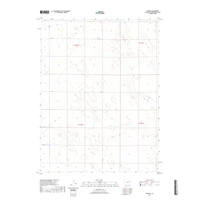
2019 Map of De Nova
USGS Topo · Published 2019About this map
Jack Creek winds through the northwestern corner of this Washington County landscape, which is defined by the rigid geometry of the Public Land Survey System. The map documents the vast agricultural and open spaces of northeastern Colorado, where the transition between t2s r50w and t2s r49w is marked by a sparse network of section-line roads. These routes, such as Co Rd 17 and Co Rd 20, provide the primary infrastructure for this rural expanse. The terrain is characterized by subtle elevation changes and the presence of ephemeral water features typical of the High Plains. While largely devoid of named settlements, the map provides a detailed record of the road system, including Co Rd 14 and Co Rd Tt, which facilitate movement across the sprawling township boundaries of the region.
Find a feature on this map
13 named features on this map. Tap any name to fly to it.
Don’t see what you’re looking for? This feature index may not catch every label — zoom into the map to look around manually.
Map Details
Editions of this 2019 De Nova Map
This is the sole edition of this map. No revisions or reprints were ever made.
Other maps of this area

1954 · Limon
USGS Topo · 1:250,000

1957 · Limon
USGS Topo · 1:250,000

1958 · Limon
USGS Topo · 1:250,000

1974 · De Nova SE
USGS Topo · 1:24,000
1974 · De Nova NE
USGS Topo · 1:24,000
1974 · De Nova NW
USGS Topo · 1:24,000

1977 · Cope
USGS Topo · 1:24,000

1977 · Arickaree
USGS Topo · 1:24,000
1977 · Elba NE
USGS Topo · 1:24,000

1977 · Elba SE
USGS Topo · 1:24,000