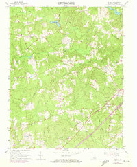
1963 Map of De Witt
USGS Topo · Published 1972About this map
De Witt and its surrounding rural communities are captured in the early 1960s, defined by a landscape of creek drainages and small crossroads settlements. The Seaboard Coast Line railroad cuts diagonally across the southeastern corner, anchoring the village of De Witt where the De Witt Sch, Bott Memorial Ch, and Mt Calvary Ch are clustered. This period shows a transition in land use, as traditional family landmarks like the Meredith Cem and Booth Cem sit alongside more modern infrastructure including a large Pipeline and Telephone lines traversing the timbered terrain. The northern half of the map is particularly water-dense, featuring Colemans Lake and the branching reaches of White Oak Creek and Butterwood Creek. Small commerce and social hubs like Wilkinsons Store and Baltimore Corner demonstrate the dispersed nature of Dinwiddie County's rural geography.
Find a feature on this map
34 named features on this map. Tap any name to fly to it.
Don’t see what you’re looking for? This feature index may not catch every label — zoom into the map to look around manually.
Map Details
Editions of this 1963 De Witt Map
3 editions found
Other maps of this area

1897 · Amelia
USGS Topo · 1:125,000

1918 · Lawrenceville
USGS Topo · 1:62,500

1919 · Mc Kenney
USGS Topo · 1:48,000

1920 · Lawrenceville
USGS Topo · 1:48,000

1921 · Mc Kenney
USGS Topo · 1:62,500

1921 · Lawrenceville
USGS Topo · 1:62,500

1942 · Lawrenceville
USGS Topo · 1:62,500

1943 · Mc Kenney
USGS Topo · 1:62,500

1943 · De Witt
USGS Topo · 1:24,000

1943 · Dinwiddie
USGS Topo · 1:24,000