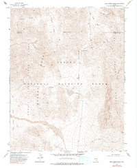
1973 Map of Dead Horse Ridge
USGS Topo · Published 1990About this map
The Desert National Wildlife Range dominates this landscape, reflecting a period of mid-century federal land management where conservation and military utility converged. The western portion of the map is occupied by the Nellis Air Force Range, defined here by a series of Restricted zones and a distinct Military Reservation Boundary. The terrain is characterized by steep elevation shifts, rising from the Three Lakes Valley up to the high crest of Dead Horse Ridge and Saddle Mountain. Settlement is absent, replaced by specialized infrastructure like the Sheep Pass Guzzler, a wildlife watering station. Transportation is limited to unimproved tracks such as Alamo Road and Dead Horse Road, which navigate between prominent geographical features like Surprise Canyon and Snow Basin. The map also captures the administrative division between Lincoln and Clark counties along an Indefinite Boundary.
Find a feature on this map
19 named features on this map. Tap any name to fly to it.
Don’t see what you’re looking for? This feature index may not catch every label — zoom into the map to look around manually.
Map Details
Editions of this 1973 Dead Horse Ridge Map
2 editions found
Other maps of this area

1907 · Las Vegas
USGS Topo · 1:250,000

1908 · Las Vegas
USGS Topo · 1:250,000

1945 · Sheep Range
USGS Topo · 1:125,000

1954 · Las Vegas
USGS Topo · 1:250,000

1957 · Las Vegas
USGS Topo · 1:250,000

1959 · Las Vegas
USGS Topo · 1:250,000

1960 · Hayford Peak
USGS Topo · 1:62,500

1962 · Las Vegas
USGS Topo · 1:250,000
1969 · Mule Deer Ridge
USGS Topo · 1:24,000
1969 · Mule Deer Ridge NW
USGS Topo · 1:24,000