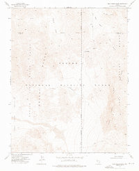
1973 Map of Dead Horse Ridge
USGS Topo · Published 1976About this map
Desert National Wildlife Range defines this high-desert landscape in the early 1970s, where the Desert Range meets the Nellis Air Force Range. The topography is marked by a series of north-south elevations, including Dead Horse Ridge and East Ridge, separated by arid basins like Snow Basin and Surprise Basin. Human presence is minimal and highly specialized, represented by the winding Alamo Road and the remote Dead Horse Trail.
Find a feature on this map
17 named features on this map. Tap any name to fly to it.
Don’t see what you’re looking for? This feature index may not catch every label — zoom into the map to look around manually.
Map Details
Editions of this 1973 Dead Horse Ridge Map
2 editions found
Other maps of this area

1907 · Las Vegas
USGS Topo · 1:250,000

1908 · Las Vegas
USGS Topo · 1:250,000

1945 · Sheep Range
USGS Topo · 1:125,000

1954 · Las Vegas
USGS Topo · 1:250,000

1957 · Las Vegas
USGS Topo · 1:250,000

1959 · Las Vegas
USGS Topo · 1:250,000

1960 · Hayford Peak
USGS Topo · 1:62,500

1962 · Las Vegas
USGS Topo · 1:250,000
1969 · Mule Deer Ridge
USGS Topo · 1:24,000
1969 · Mule Deer Ridge NW
USGS Topo · 1:24,000