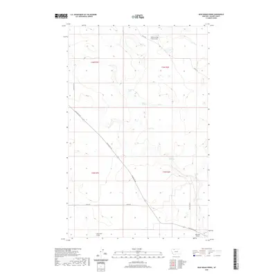
2020 Map of Dead Indian Spring
USGS Topo · Published 2020About this map
Dead Indian Spring serves as a central landmark in this portion of Glacier County, situated among a network of drainages and intermittent water sources. The landscape is defined by its coulees, most notably East Fork Big Rock Coulee and Little Rock Coulee, which dictate the local topography and the paths of the few established roads. Vital water points such as Coyote Springs and Dripping Hole Spring are mapped with precision, highlighting their importance in this arid environment. Transportation across the quadrangle relies on a sparse network of rural routes, including Chalk Butte Rd and Reagan Rd, which navigate the elevation changes between the plains and the coulee floors. The map illustrates a section of the American West where land use is closely tied to the availability of water and the natural corridors carved by ancient drainage patterns, such as Big Rock Coulee.
Find a feature on this map
14 named features on this map. Tap any name to fly to it.
Don’t see what you’re looking for? This feature index may not catch every label — zoom into the map to look around manually.
Map Details
Editions of this 2020 Dead Indian Spring Map
This is the sole edition of this map. No revisions or reprints were ever made.
Other maps of this area

1907 · Blackfoot Res.
USGS Topo · 1:48,000

1909 · Cut Bank
USGS Topo · 1:125,000

1911 · Blackfoot
USGS Topo · 1:125,000

1912 · Cut Bank
USGS Topo · 1:125,000

1960 · Cut Bank
USGS Topo · 1:250,000

1963 · Cut Bank
USGS Topo · 1:250,000

1964 · Cut Bank
USGS Topo · 1:250,000
1966 · Cut Bank
USGS Topo · 1:24,000
1966 · Gunsight
USGS Topo · 1:24,000

1968 · Headlight Butte NE
USGS Topo · 1:24,000